Maui's Weak High Tides in Winter
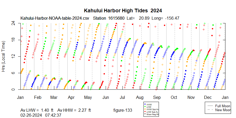
Here is a plot of NOAA high tide predictions for Kahului Harbor, Maui, in 2023:
Watersport folks know that the shallow reefs in Kanaha Beach Park become problematic during winter, and this plot shows clearly how different winter is from summer in Maui in the mid-day.
Terminology: "Diurnal" means a once daily tide. Semi-diurnal means twice per day. One might think that a word that begins "di-" would mean twice per day, since the Greek root prefix "di-" implies twice. However, the etymology for diurnal is Latin, from dies (day), diurnus (daily).
Many US ports have mainly semi-diurnal tides. That means there will usually be two unequal high tides and two low tides. The highest high tide is known as the "high high water (HHW)", and the lower high tide is the "low high water (LHW)". Maui has been classified as "mixed, mainly semi-diurnal." In 2024 Maui will have 286 days with two high tides. On semi-diurnal days, there is a high tide associated with the Moon's zenith transit overhead, and also with the Moon's zenith transit on the far side of the Earth.
The tidal range at Maui is relatively small, with the lowest tide in 2024 predicted at -.74 ft on Jan 12, and the highest tide at 2.99 ft on July 22 and Aug 20. The mean water level for the year is 1.1 ft. Why not 0.0? In the US tides are measured from MLLW, or mean lower low water. That is why you see fewer negative than positive tides. All the predictions are offset upwards from mean sea level by +1.12 feet.
Is Maui Unusual?
For US ports, yes. Have a look at San Francisco, below:
Very regular, no holes. You might object that San Francisco is at a very different latitude than Maui, 37N vs 21N. There is no other US port at 20N, but here is Fiji at 20S:
However, take a look at this figure for Puerto Vallarta, 2024:
Puerto Vallarta is at the same latitude as Maui and shows a similar set of "holes", although they seem to be inverted in local time. The closest US port would be San Diego, and here are the high tides for La Jolla:
La Jolla is significantly north of Puerto Vallarta, latitude 33N vs 21N, but you can almost see the "holes" developing. What is it about the 20th parallel in the Pacific?


Comments
Post a Comment